Temple of the Soul's Retreat

An Indian Buddhist monk and pilgrim, named Huili in Chinese, travelled to Hangzhou in 326 AD. Huili founded Lingyin Temple, which can be translated as Temple of the Soul's Retreat or Temple of Inspired Seclusion. At that time Buddhism in China attracted a relatively small number of followers and early Lingyin Temple was pretty secluded. During the Southern and Northern Dynasties (420-589AD) Buddhism was on the rise. Xiao Yan, Emperor Wu of Liang Dynasty (504 AD), ordered that people should "abandon Taoism and return to Buddhism", but during the following dynasties Buddhism fell in and out of favour many times, and Lingyin Temple declined and prospered along with the mood of the times.

In modern times Lingyin Temple survived the Cultural Revolution (1966-1976) after former Prime Minister Zhou Enlai (1898-1976) suggested "temporary closure of Lingyin Temple" to protect the temple. While a surprising number of buildings in the temple complex are modern, the history can be traced back more than 1680 years.

The whole temple compound is large. I strolled around the various buildings in almost 5 hours.

temple-soul-2.jpg

Feilai Feng, or "the Peak that Flew Hither", is said to have inspired Huili to settle in this place. The craggy peaks reminded Huili of a mountain in India. Many statues are carved into the limestone rock over the course of many centuries.

temple-soul-3.jpg

The Hall of the Four Heavenly Kings is the former entrance to Lingyin Temple. In the photo are the eastern King Dhṛtarāṣṭra (持國天王) with the four-stringed Chinese musical instrument and the southern King Virūḍhaka (增長天王).

temple-soul-10.jpg

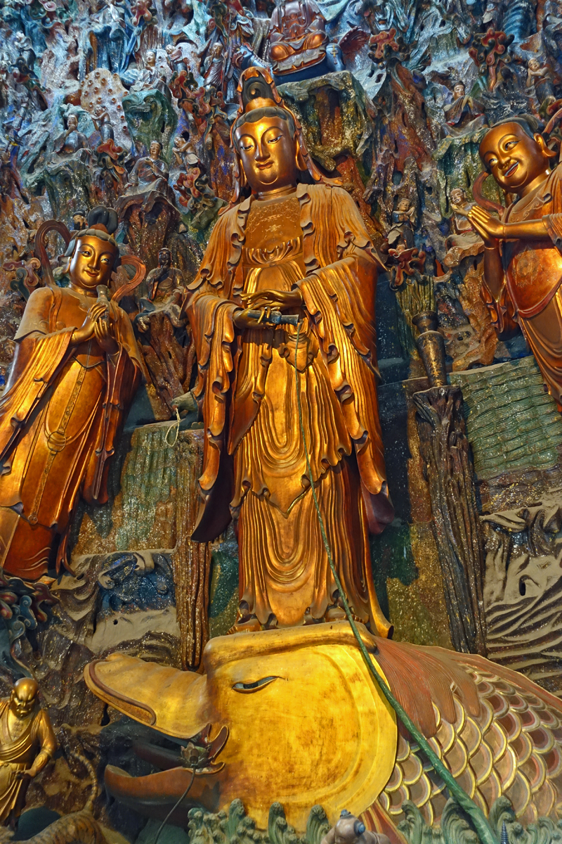
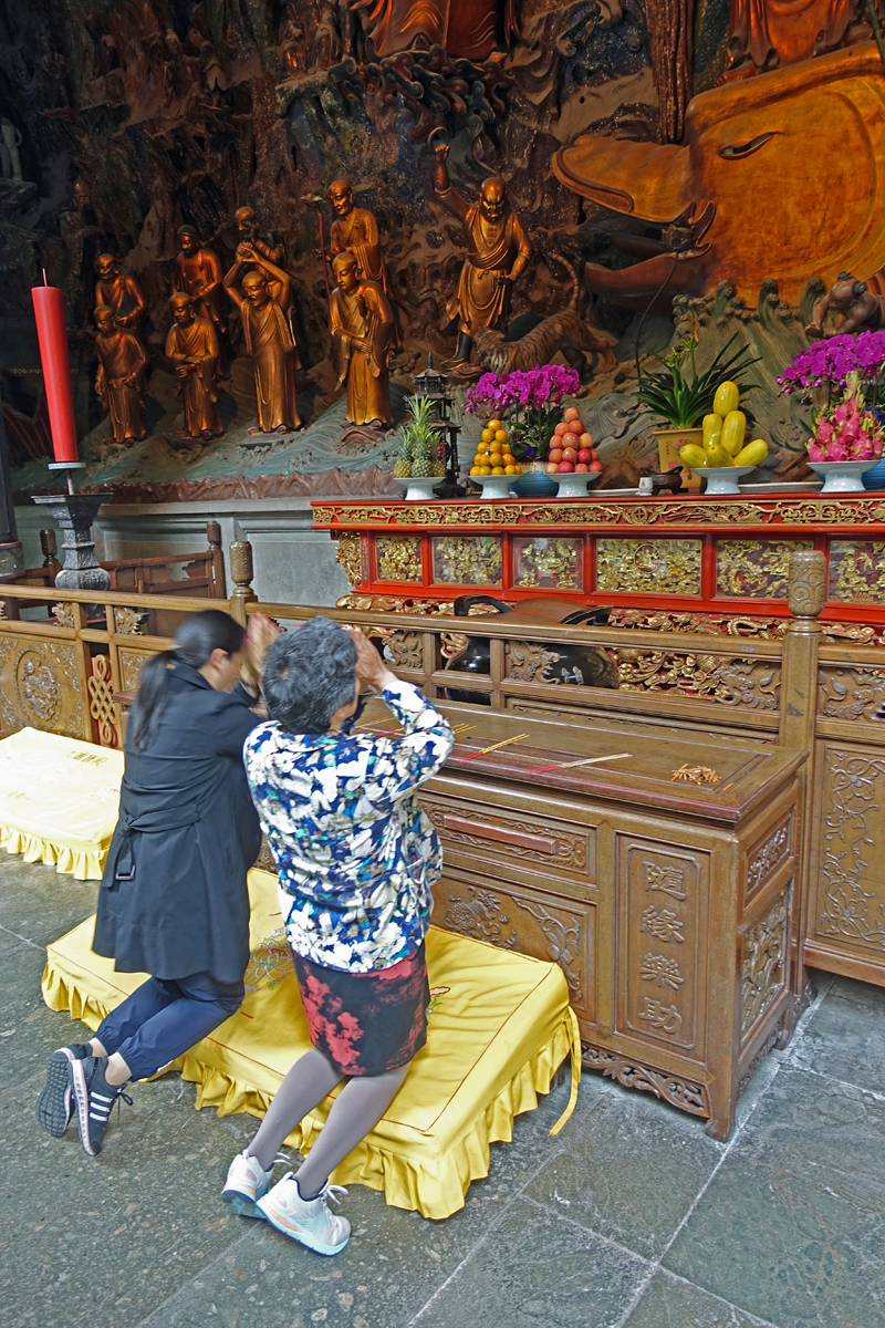
Below: Guanyin, a manifestation of the Bodhisattva Avalokiteśvara, with relief screen, at the back of the Grand Hall of the Great Sage.

temple-soul-5.jpg
temple-soul-8.jpg

Some, but not all, Buddhist schools advocate vegetarianism. In practice monks and nuns are expected to abstain from meat. Lingyin Temple has a vegetarian restaurant although there was some confusion on my part if I found the right restaurant, since there was also chicken on the menu. I ordered a vegetarian noodle soup, fresh bamboo shoots with preserved vegetables and a simple version of Buddha's delight without soy sauce.

temple-soul-6.jpg

Longjing tea 龍井茶

Almost 15 years ago I bought Longjin tea online from China. Since then, for me, the name Longjin (lit: Dragon Well) is synonymous with Chinese green tea. But what do you get if you buy Longjing? Many teas are sold under the name Longjing. They might be from a completely different area. Authentic Longjing tea comes from the Zhejiang Province, which is still a vast area. Stricter definitions confine the tea to Xihu District, Hangzhou.

I took a taxi to Longjing village, in the middle of Xihu District. The buds are picked in March and April, before Qingming Festival, which falls on the 15th day from the Spring Equinox in the first week of April. I arrived a few weeks after the first harvest and many tea growers were pruning the tea bushes with motorised hedge trimmers. It was noisy and decaying, brown leaves were everywhere.

I wandered about until I got to Hugongmiao Temple (胡公庙). Inside the temple area there is a tea house, where you can buy expensive tea ware and, of course, Longjing tea. I ordered one glass of Longjing tea at ¥ 98. While I contemplated my € 13 tea, it sunk in I had just arrived in China. On my first day I already made a long wish come true. The veranda of the tea house was quiet and peaceful. The pale yellow tea leaves were dancing in the water and slowly sinking to the bottom. Life was good for a moment.

longjing-1.jpg
longjing-2.jpg
longjing-4.jpg

There are many legends surrounding Longjing tea. Qianlong Emperor (Reign: 1733–1735) is said to have visited West Lake during one of his holidays. He went to Hu Gong Temple and was presented with a cup of Longjing tea. In front of the Hu Gong Temple were 18 tea bushes. The Qianlong Emperor was so impressed by the Longjing tea produced here that he conferred these 18 tea bushes special imperial status. The 18 tea bushes are still there, although I am sceptical of that claim, to put it mildly.

The 18 imperial tea bushes.

The 18 imperial tea bushes.

Qianlong Emperor (25 September 1711 – 7 February 1799)

Qianlong Emperor (25 September 1711 – 7 February 1799)

Longjing Village

Longjing Village

Recognising Longjing is quite easy, knowing exactly what you are looking at is very complicated, or nearly impossible. Several different varietals are growing in the region. Longjing Qunti, which is referred to by locals as lao shu, or ‘old tree varietal’, is the same varietal Emperor Qianlong would have tasted. A second varietal is called Longjing #43, or locally xin shu, ‘new tree varietal’, which was introduced later to yield small, perfect, early buds. Longjing #43 also buds earlier, which will yield a much higher price for the tea. The very first Longjing of the year is sold at inflated prices. However, it is easy to sell #43 varietal and claim the small buds are a sign of early picked leaves, while they are not. You can end up paying too much for your Longjing tea leaves because it is difficult to tell if they were indeed picked in Xihu District, at which elevation and at which date, 'pre-qingming' (清明前) or not. Many resellers don’t even know. I bought 50 grams Longjing in Longjing Village in what looked like a reliable shop for ¥ 200, which is at least the right price for the real deal.

Pan-firing Longjing tea leaves. Leaves are hand roasted for 15 minutes immediately after picking to prevent oxidisation. After cooling down and the final selection, the leaves are pan-fried one more time before packaging. Shared under: GNU General P…

Pan-firing Longjing tea leaves. Leaves are hand roasted for 15 minutes immediately after picking to prevent oxidisation. After cooling down and the final selection, the leaves are pan-fried one more time before packaging. Shared under: GNU General Public License.

Harzreise im Winter

Some journeys you regret on the very first day and it doesn’t get any better on the second or even last day. My ‘Silvester 2018’ trip was such a journey. The Harz is a beautiful nordic mountain range, with an exposed cold and windy summit, large pine forests, deep gorges, romantic restaurants, and - even though most Grimm Brothers’ fairytales were not exactly from the Harz - it is easy to imagine they were once passed on from generation to generation in the deep forests.

I came looking for Waldeinsamkeit - a key concept in German romanticism - but within the romantic framework it is seen as a positive feeling. I just felt loneliness. For three straight days I was haunted by the memory of long lost loves. Maybe I should have avoided people at all, like a hermit. The moment I wandered off path, for a picnic among the pine trees I felt sort of okay, munching on a piece of dried Hirsch (deer meat) and making hot drip coffee for myself. Seeing other people reminded me too much of being single.

Der Gipfel des Nordens

On the first day I hiked from Drei Annen Hohne to the Brocken and back again. A day trip considering the short days of December. At 1142 meters the Brocken is not very high, but being at a latitude relatively close to the North Pole, the climate is brutal. The average temperature on the summit is comparable to the 1600 to 2200 meter zone in Iceland. You can hike up to the Brocken in fair weather only to see the weather change dramatically in the last half an hour before reaching the summit. Most of the year there will be no view at all. The Brocken is hidden in mist for 306 days a year on average. To add to the mystery: between 1961 and 1990 the mountain was a military zone in the former GDR and could not be visited at all.

Blocksberg

In connection with the Brocken witches the mountain is named Blocksberg. As early as 1485 the Brocken was referred to as “Blokkesberghe”, but despite the documented (and very real) 15th to 17th century witch-hunts, the Brocken witches are in essence a modern 19th century fantasy. The first organised Walpurgisnacht on the Brocken dates back to 1896, with only male guests attending. It was really the early 20th century tourist industry, which promoted Walpurgisnacht on the Brocken.

Iced summit of the Brocken. On December 30 it was even too cold for witches. But because of the holidays the tourists did come, in large numbers. I just pointed my camera the other way.

Iced summit of the Brocken. On December 30 it was even too cold for witches. But because of the holidays the tourists did come, in large numbers. I just pointed my camera the other way.

Undated postcard celebrating Walpurgisnacht on the Brocken.

Undated postcard celebrating Walpurgisnacht on the Brocken.

Many pine trees in the Harz are dying because of the bark beetle (Borkenkäfer). While dead pine trees are a sorry sight, it is also a sign that the forests are not diverse enough. In the Harz pine trees have been planted by man for many centuries. T…

Many pine trees in the Harz are dying because of the bark beetle (Borkenkäfer). While dead pine trees are a sorry sight, it is also a sign that the forests are not diverse enough. In the Harz pine trees have been planted by man for many centuries. The trees were a valuable source of timber. As early as the 15th century the bark beetle caused mass mortality of pine trees. When pine trees die, pioneering broad-leaved trees will take their place.

#nurliebe (only love)

#nurliebe (only love)

Lunch with local Harzer Käse (not to be confused with Harzkäse) and Schmorwurst.

Lunch with local Harzer Käse (not to be confused with Harzkäse) and Schmorwurst.


Teufels Brücke

On my second day I hiked the Bodetal from Thale to Treseburg (population 92) and back. When crossing the Teufels Brücke I would have easily sold my soul in blood in return for love, if I had encountered Mephisto, or even a black poodle. The bridge leads to a ten kilometre long gorge with no escape until Treseburg. Despite my negative feelings on this trip I will certainly find my way back to the Harz. I have a special place in my heart for this ancient mountain range.

harz-5.jpg
Faust und Mephisto im Kerker, 1848. Joseph Fay (1812-1875).

Faust und Mephisto im Kerker, 1848. Joseph Fay (1812-1875).

Bodetal (Bode Gorge) home to the wildcat.

Bodetal (Bode Gorge) home to the wildcat.

In winter you have to ignore the “Achtung Lebensgehar!”-signs.

In winter you have to ignore the “Achtung Lebensgefahr!”-signs.

Hauseigener Glühwein. With drinking too many glasses of this hot and sweet mulled wine the fate of New Year’s Eve 2018 was sealed. I went to bed in my hotel at 7 pm with spinning head. It is starting to feel like a tradition; missing all New Year’s …

Hauseigener Glühwein. With drinking too many glasses of this hot and sweet mulled wine the fate of New Year’s Eve 2018 was sealed. I went to bed in my hotel at 7 pm with a spinning head. It is starting to feel like a tradition; missing all New Year’s Eve festivities. Better luck in 2019.

Pictures of Iceland

A miscellaneous collection of photos, which didn’t fit anywhere else.

The strange reason I ended up in Iceland. In October the company I work for shipped a pallet with goods from Amsterdam to Chicago (ORD) with Icelandair Cargo via Liege (LGG) and KEF. The pallet never arrived at its intended destination in ORD. To ma…

The strange reason I ended up in Iceland. In October the company I work for shipped a pallet with goods from Amsterdam to Chicago (ORD) with Icelandair Cargo via Liege (LGG) and KEF. The pallet never arrived at its intended destination in ORD. To make sure the shipment was not lost in Iceland I called Icelandair Cargo in KEF and asked for an investigation. In the above security camera image you can see our pallet with 12 boxes arriving from LGG in KEF. The next image I received shows our shipment leaving KEF for its flight to ORD aboard an Icelandair passenger plane. It convinced me our shipment had been lost in the USA. Since the girl on the phone in Iceland was really friendly, I ended up buying a ticket with Icelandair to KEF for a short holiday.

Church with graveyard near Hveragerði.

Church with graveyard near Hveragerði.

The graveyard near Hveragerði close-up.

The graveyard near Hveragerði close-up.

Sheep heads in a supermarket in Hveragerði. Unfortunately restaurant Myrin Mathus in Reykjavík was closed due to renovation. This was the closest I got to eating Svið.

Sheep heads in a supermarket in Hveragerði. Unfortunately restaurant Myrin Mathus in Reykjavík was closed due to renovation. This was the closest I got to eating Svið.

In winter the Icelandic Road and Coastal Administration closes many roads if they are deemed unsafe. You can drive past the sign, but then your car insurance will be void.

In winter the Icelandic Road and Coastal Administration closes many roads if they are deemed unsafe. You can drive past the sign, but then your car insurance will be void.

Snow mobile tour operator Mountaineers of Iceland operates a fleet of specially modified buses to reach glaciers and other remote locations.

Snow mobile tour operator Mountaineers of Iceland operates a fleet of specially modified buses to reach glaciers and other remote locations.

Tourist centre near waterfall Gullfoss. I love how the architecture blends with the landscape.

Tourist centre near waterfall Gullfoss. I love how the architecture blends with the landscape.

Hvalfjörður, meaning: whale-fjord, before sunrise. In Hvalfjörður the only remaining whaling station of Iceland is located.

Hvalfjörður, meaning: whale-fjord, before sunrise. In Hvalfjörður the only remaining whaling station of Iceland is located.

Santa Clauses in fishing town Akranes. There is always one who doesn’t fit in.

Santa Clauses in fishing town Akranes. There is always one who doesn’t fit in.

House in Akranes

House in Akranes

I really liked driving this 2018 Suzuki Vitara all grip, which is the 4x4 version.

I really liked driving this 2018 Suzuki Vitara all grip, which is the 4x4 version.

Close to nothing

Only on my flight back to Amsterdam I was able to put the Icelandic landscape in some sort of context when I watched the documentary Horizon (original title: Sjóndeildarhringur) about Icelandic painter Georg Guðni (1961 - 2011). Coming of age in the rebellious punk scene of the 80s in 1983 Georg Guðni suddenly turned his attention to the Icelandic landscape, at first painting particular mountains but soon painting non-particular mountains and horizons. He put quite some thought into the act of looking itself.

The spectacular has never inspired me. I am much more inspired by all that is in between. When you are driving to some spectacular destination. There is so much on the way that simply does not catch your eye. The scenery that passes by your window, which means nothing to you. This is what inspires me.
— Georg Guðni
Landscape near the waterfall Gullfoss.

Landscape near the waterfall Gullfoss.

gudni-750x400.jpg
In regard to the horizon, it is the nothing that is in between, and it is this nothing that you look at when you forget that you are looking out of the window. You are not looking. You are just thinking. You search for something to see, but you don’t see anything.
— Georg Guðni
Untitled, 2002

Untitled, 2002

His death is never mentioned in the documentary, but it seems that he took his own life at 50. The male suicide rate in Iceland is high (21,7 per 100.000 people) compared to the female suicide rate (4,7).

The book Strange Familiar - The Work of Georg Gudni was published by Perceval Press (2005), ISBN 0-9747078-9-9.

Condensed water vapour of the geyser Strokkur.

Condensed water vapour of the geyser Strokkur.

Vulcano Katla and beyond

On my fifth day in Iceland I ventured out towards the south part of the island. First stop was the village Vík í Mýrdal just below the volcano Katla. This volcano is very active. Twenty eruptions have been documented between 930 and 1918, at intervals of 20–80 years. Many times an eruption of the smaller volcano Eyjafjallajökull was followed by an eruption of Katla. Eyjafjallajökull last erupted in 2010 resulting in air-traffic shut-down in parts of Canada and all of Europe including Ukraine and Belarus. Katla is a ticking time bomb. The Vulcano is also one of the largest volcanic sources of carbon-dioxide (CO2) on Earth, accounting for up to 4% of total global volcanic carbon-dioxide emissions. When Katla erupts the glacier covering the Vulcano will melt causing floods, which will probably destroy the village Vík.

Vík has a population of 318 and a beautiful black beach. The stones are actually grey but when wet become shiny and black. The day was very cloudy and rainy so I couldn’t get a view of the volcano.

The eruption of Katla in 1918 lasted for 24 days. The eruption resulted in extending the southern coast by 5 km due to a mudflow. Since then the sea has reclaimed the land and is even threatening the village. A newly built breaker halts the process.

The eruption of Katla in 1918 lasted for 24 days. The eruption resulted in extending the southern coast by 5 km due to a mudflow. Since then the sea has reclaimed the land and is even threatening the village. A newly built breaker halts the process.

katla-1.jpg
katla-2.jpg
Lamb stew at a gas station in Vík

Lamb stew at a gas station in Vík

It was still early enough to drive on. In theory I could just reach Vatnajökull, a glacier covering 9% of Iceland, and its glacial lagoon. It was still another 2,5 hours and it meant I had to drive the whole distance back in the dark. I could always try to find a hotel I thought, although a quick Booking.com search learned that the cheapest option would cost almost a hundred euro. Still, I drove on, through a large very empty plain. The weather didn’t improve. There was no view whatsoever and the weather forecast for the next day was even worse. On a 150 kilometre stretch the only interesting bit was a pile of rocks where there used to be a house, but they are not really sure if there really was a house. Travellers pile rocks on each other for good luck and the government made a parking space and an information sign.

katla-3.jpg
katla-6.jpg

I never reached Vatnajökull and the beautiful glacial lagoon Jökulsárlón. I reckoned that the time I would reach Jökulsárlón it was practically dark and due to the weather I wouldn’t see much anyway. The whole endeavour also was a waste of money since the Suzuki was thirsty. In the middle of nowhere I made a U-turn and drove back to Reykjavík.

Expression of the Icelandic landscape in pottery by Glit Pottery (1958-1971). From 1972 the company operated at Höfth instead of Reyklavík. Pieces of lava are incorporated in the clay before glazing.

Expression of the Icelandic landscape in pottery by Glit Pottery (1958-1971). From 1972 the company operated at Höfth instead of Reyklavík. Pieces of lava are incorporated in the clay before glazing.

Snæfellsnes

In Voyage au centre de la terre by Jules Verne, Professor Lidenbrock and his nephew Axel start the journey to the center of the earth in the crater of the jökull of Snæfell after deciphering a coded note written in runic script:

“Descend, bold traveller, into the crater of the jökull of Snæfell, which the shadow of Scartaris touches (lit: tastes) before the Kalends of July, and you will attain the centre of the earth. I did it. Arne Saknussemm”

My journey to Snæfellsnes was somewhat less adventurous. For a start I had a very comfortable Suzuki Vitara 4x4 to my disposal. Still, Snæfellsnes is a really deserted place. I first drove to Borgarnes for a stopover and black coffee, but it was still dark when I reached Borgarnes. The live traffic service of my TomTom navigation showed many exclamation marks (!!!!!!) along the way, but I decided to ignore those. I entered Hellnar as a destination since it has a restaurant. Or so I thought.

verne_1.jpg

At a gas station I learned that a big storm was going to hit Iceland around coffee time. “What time is that?”, I had to ask. “Around 4 o’clock”, I learned. The Road and Coastal Administration (IRCA) advised to avoid driving after that time. Suddenly I had a time schedule.

verne_8.jpg
verne_2.jpg

After driving for more than 5 hours since I left Reykjavík I found the only restaurant in Hellnar closed. Not many people visit Hellnar in wintertime and for good reasons. Hellnar is not much more than a small church, the closed hotel-restaurant and a few scattered buildings. In 1703 there were 194 people registered as inhabitants of Hellnar. Since then the village has declined, no more fish is being landed here. But it is the gateway to Snæfellsjökull National Park. Since I was getting really hungry I had little choice than to keep on driving, trough the park to Ólafsvík, the nearest village, boasting a population of 1.010.

verne_7.jpg
The church of Hellnar built in 1945 on the site of an older church.

The church of Hellnar built in 1945 on the site of an older church.

Hellnar

Hellnar

Harbour of Ólafsvík.

Harbour of Ólafsvík.

Fresh cod in SKER Restaurant, Ólafsvík. Nice touch were thin slices of cauliflower marinated in vinegar.

Fresh cod in SKER Restaurant, Ólafsvík. Nice touch were thin slices of cauliflower marinated in vinegar.

verne_5.jpg
verne_6.jpg

Svarta Kaffi

Amazingly we know exactly when coffee arrived in Iceland. Coffee arrived precisely on November 16, 1703, “when Árni Magnússon – a scholar and collector of many highly valuable Nordic manuscripts – acquired a quarter of a pound of coffee from a friend.” By the mid-19th century, drinking coffee had become a daily habit. When driving in Iceland I stopped at every gas station for a cup of black coffee - or in practice every hour or so. The last hour and a half before arriving back in Reykjavik the storm hit the island, heavily. My speed dropped from 90 to 30 kilometres per hour so the car wasn’t blown off the road. The round trip from Reykjavík took me 10 hours.

verne_9.jpg
verne_10.jpg

Harnessing geothermal energy at Friðheimar

It is not easy to grow fruit and vegetables in Iceland. Fruit is readily available but is mostly flown in by Icelandair Cargo on a daily cargo flight from Liege in Belgium, which is also close enough to The Netherlands. The couple Knútur and Helena are growing tomatoes all year round near Selfoss in a farm called Friðheimar. A borehole 200 meters from the greenhouses provides water at about 95°C. To make most of the light, which is needed in wintertime to grow the tomatoes, the restaurant is located right in one of the greenhouses. It makes a very welcome moment in the dark moments of the day. For the price of the tomato soup you can serve yourself as many times you like, even the coffee is free if you order the soup. Dutch bees are pollinating the plants. It was one of the strangest restaurants I have eaten in. Perfect cure for seasonal affective disorder (SAD) though!

Fridheimar_1.jpg
Fridheimar_3.jpg
Fridheimar_2.jpg

Once ruled by the House of Medici

Just below the Campo Imperatore there are several beautiful medieval hill towns: Santo Stefano di SessanioCastel del Monte, Calascio and the mountaintop fortress Rocca Calascio are the most interesting.

I spent time just hanging out in these villages, drinking coffee, speaking to cats and reading news on my iPhone.

The area was shaped by transhumance. Local animal products were sought after during the Middle Ages and the Renaissance. Carfagna sheep wool was transported to Florence and mainly used to produce military uniforms and monks' cowls. The villages lost importance during the 19th century. Once ruled by the House of Medici, Santo Stefano di Sessanio counted 3.000 people in 1870. In 2005 there were only 80. 

Porta Medicea, branded with the coat of arms of the House of Medici.

Porta Medicea, branded with the coat of arms of the House of Medici.

italy-13.jpg
italy-26.jpg
Favola di Venezia (Hugo Pratt, 1976). Corto Maltese speaks to the street cats.

Favola di Venezia (Hugo Pratt, 1976). Corto Maltese speaks to the street cats.

The small pleasures of life in Italy: un caffè in the town square.

The small pleasures of life in Italy: un caffè in the town square.

Rocca Calascio. The fortress was destroyed by an earthquake in 1461 and never rebuilt.

Rocca Calascio. The fortress was destroyed by an earthquake in 1461 and never rebuilt.

There is no denying the villages are in bad shape due to earthquakes and neglect.

There is no denying the villages are in bad shape due to earthquakes and neglect.

The distance between the hill towns can be easily cycled, with lots of climbing and fast downhills.

The distance between the hill towns can be easily cycled, with lots of climbing and fast downhills.

Mosaic on a wall in Castel del Monte. It is hard not to imagine this mosaic was inspired by te earthquake of 2009. Castel del Monte is the principal location of The American directed by Anton Corbijn. The film's central character played by George Clooney, takes refuge in Castel Del Monte hoping to escape from his past.

Italy-25.jpg
Movie still from The American (2010), Anton Corbijn.

Movie still from The American (2010), Anton Corbijn.

Campo Imperatore

On the second day of my stay in Abruzzo I more or less stumbled upon Campo Imperatore. It was just a name on the map, but the location intrigued me: right above the middle of the 10 kilometer long Traforo del Gran Sasso I drove through to reach my destination. When I reached the mountain grassland my mouth fell open by the sheer beauty. I had not expected this. 

In the distance you can see the mountains of Gran Sasso d'Italia towering over the grasslands with the highest peak being the Corno Grande (2912 m). The northern face holds Europe's southernmost glacier: Ghiacciaio del Calderone. In 2017 the glacier disappeared for the first time mid-August.

I spent a day cycling and a day hiking in Campo Imperatore and the mountains of Gran Sasso d'Italia

italy-6.jpg
Italy-44.jpg
Italy-21.jpg
Campo Imperatore was also the backdrop of quite a few movies, like the Spaghetti Western Lo chiamavano Trinità... (1970) starring Bud Spencer and Terence Hill.

Campo Imperatore was also the backdrop of quite a few movies, like the Spaghetti Western Lo chiamavano Trinità... (1970) starring Bud Spencer and Terence Hill.

Red Sonja (1985), with Brigitte Nielsen and Arnold Schwarzenegger.

Red Sonja (1985), with Brigitte Nielsen and Arnold Schwarzenegger.

Gran Sasso d'Italia mountain massif

Italy-24.jpg
Italy-23.jpg
italy-22.jpg
Polenta with meat stewed in red wine in Rifugio Duca degli Abruzzi (2.400 m.).

Polenta with meat stewed in red wine in Rifugio Duca degli Abruzzi (2.400 m.).

Parts Unknown - Abruzzo

On my way to Abruzzo the words "Parts Unknown" were ringing through my head. I really didn't want to do this trip alone. I was reasonably sick of spending all my travels alone and this time I was even more apprehensive than normal for personal reasons. My previous long road trip didn't end well. At the same time I realised how lucky I am to own a car and have plenty of money for diesel and all the food I want to order at any restaurant along the way. Anthony Bourdain was even more fortunate, yet five days after photos of his love of his life hugging another man in the streets of Rome were published, he committed suicide. Bourdain was the presenter of the long running (11 seasons) travel and food series Parts Unknown. I kinda get the loneliness he must have felt. Just kinda. I do not want to pretend to understand the depressions he was suffering. My journey to Italy was marred by an intense feeling of loneliness.

Empty glass, yet "un quarto di litro di vino rosso".

Empty glass, yet "un quarto di litro di vino rosso".

I planned to cycle a 388 kilometer loop through Gran Sasso National Park, Abruzzo National Park and Sirente Velino Regional Park. The loop was envisioned by Giorgio Frattale and Francesco D’Alessio who cycled this trip in 5 days. On day one I loaded my bike with my tent and plenty of food and water. The sky was partially cloudy and my bike felt heavy. After half a day I calculated my progress in distance and it became quickly clear I would never finish the loop in 5 days. My plan had quickly crumbled to pieces. Time for plan B. There's always a plan B.

Turning point.

Turning point.

I decided to spent the first night camping in the mountains. I choose a spot between Santo Stefano di Sessanio and Calascio with a beautiful valley view. I pitched my Tarptent Double Rainbow at dusk and waited for the night to fall. Soon I could hear animals trampling the grass around my tent. I assume the Apennine wolf keeps his distance from the lower valleys, so it must have been - well, god knows what.

italy-3.jpg
italy-5.jpg
Serene early morning in the mountains. Absolute silence.

Serene early morning in the mountains. Absolute silence.

La vita è bella

La vita è bella

A much lighter bike for day trips. Plan B wasn't so bad after all.

A much lighter bike for day trips. Plan B wasn't so bad after all.

Final few kilometres of my holiday, just before the brake pads of my disc brakes were completely worn out and my braking power was reduced to almost nothing.

Final few kilometres of my holiday, just before the brake pads of my disc brakes were completely worn out and my braking power was reduced to almost nothing.

Tour de Achterhoek

In Thailand I felt silly I was hesitating to rent a scooter. I never rode one of these machines. Now I finally did, close to home. I rented a Taiwanese SYM Cello in Groenlo from a rental company called Tour de Achterhoek. Technically this was "snorfiets" according to Dutch law (the word "snorfiets" in the law dates from 1974, colloquially you would say "snorscooter"), which means the maximum speed is 25 km/h, there is no obligation to wear a helmet and the number plate is blue. Technically there is not much difference between a "snorscooter" and a "bromscooter", which can go up to 45 km/h and carries a yellow number plate. Both fall in the category "bromfiets" and can be driven with driver's license B, which automatically is also licence AM (bromfiets) and even license T (tractors).

It was kinda fun. First thing I had to learn is to reduce speed in the curves. On my bicycle I am used to take curves quite fast but a scooter is so much more heavier. Now I can rent a scooter in Asia and not die instantly in local traffic.

IMG_6065.jpg

Parked at the pig farm (H)eerlijk Vlees near Groenlo. The family raises pigs, who get slaughtered at slaughterhouse Beerten in Zieuwent. The meat is sold at the farm behind that green door.

IMG_6056.jpg

Route der Industriekultur

The German former industrial powerhouse, the Ruhrgebiet, boasts a dense network of bicycle paths and routes called: Industriekultur per Rad. You can follow two long distance cycling routes: the RuhrtalRadweg (240 kilometers) and the Römer-Lippe-Route (400 kilometers), but in between these long distance cycling paths there is a Dutch inspired bicycle junction network - "ein modernes Knotenpunktsystem nach niederländischem Vorbild" - which brings the total amount of bicycle paths to 1200 kilometers. However, there are many more dedicated routes. Just the Römer-Lippe-Route crosses over twenty other signed bicycle routes.

I cycled part of the Emscher Park Radweg - yet another long distance (230 kilometers) route part of the Industriekultur per Rad. Starting point was the UNESCO World Heritage Site Zollverein Coal Mine Industrial Complex.

Zeche Zollverein Schacht XII is probably the most famous coal mine shaft. Designed by architects Fritz Schupp (1896-1974) and Martin Kremmer (1894-1945) in typical style of das Neue BauenIt was finished in 1932. 

industrie-4.jpg
industrie-2.jpg
Der Kamin von Zollverein war höher als die Reinoldikirche
— Information sign at Zollverein
industrie-3.jpg
Halde Rheinelbe, about 100 meters above sea level. A coal mine spoil tip.

Halde Rheinelbe, about 100 meters above sea level. A coal mine spoil tip.

Intersection of the Emscher Park Radweg and one of the many towns between Essen and Bochum.

Intersection of the Emscher Park Radweg and one of the many towns between Essen and Bochum.

Cycling path on the abandoned railway bridge 'Rote Brücke' (1926–1928) used by the former Erzbahn connecting the steelworks of the Bochumer Verein with the Rhein-Herne-Kanal.

Cycling path on the abandoned railway bridge 'Rote Brücke' (1926–1928) used by the former Erzbahn connecting the steelworks of the Bochumer Verein with the Rhein-Herne-Kanal.

An important part of cultural life in Nordrhein-Westfalen, the Biergarten.

An important part of cultural life in Nordrhein-Westfalen, the Biergarten.

Radschnellweg RS1, the first 'Autobahn' for bicycles in Nordrhein-Westfalen.

?wmode=opaque" height="480" width="854" scrolling="no" frameborder="0" allowfullscreen>

Der RuhrtalRadweg (240 kilometer)

I cycled part of the RuhrtalRadweg in the first weekend of August. Starting point of this long distance cycling path is Duisburg and the world's largest inland port. The next metropolitan area is Mühlheim an der Ruhr, then the route follows the Ruhr towards the source of the river in Winterberg, 240 kilometers further upstream and uphill.

Where the Rhein and the Ruhr meet. Rheinbrücke Neuenkamp in the background. This is also the starting or end point of the Ruhrtalradweg.

Where the Rhein and the Ruhr meet. Rheinbrücke Neuenkamp in the background. This is also the starting or end point of the Ruhrtalradweg.

Rhein-Herne-Kanal (1916) and the Ruhr. 

Rhein-Herne-Kanal (1916) and the Ruhr. 

IMG_5918.jpg
IMG_5888.jpg
The river Ruhr.

The river Ruhr.

The wide valley between Mühlheim an der Ruhr and Mintard.

The wide valley between Mühlheim an der Ruhr and Mintard.

IJmuiden

I remember the fishing harbour Scheveningen in the late 1970s. The smell of fresh fish was everywhere, mixed with the smell of tar and oil. Once a year my father bought a bucket of sprotjes (European sprat) and we would clean the fish at home and finish the whole bucket in one evening. In summertime we spent time at the beach. I still love fish and swimming in the cold waters of the North Sea. IJmuiderslag has become my favourite beach. There is no public transport connection. Therefore the beach feels more local and not as crowded as Zandvoort aan Zee - although the crazy amount of dogs is almost a dealbreaker for me. On the upside the North Sea is just as nice and the added bonus is the fishing harbour IJmuiden and probably the best sushi in The Netherlands.

IMG_5487.jpg

Fishing harbour
The old fishing harbour of IJmuiden is quite small, although you can see very big fishings ships moored in the IJmondhaven not far from the Vissershaven. The Annelies Ilena on the photo below is one of the world's largest fishing trawlers - 145 meters from bow to stern. It is no wonder the fishing harbour IJmuiden has been growing from 9.221 tonnes of landed fish in 2006 to 15.000 tonnes in 2012.

My fishmonger in Amsterdam - Vishandel Tel - opened a second store in IJmuiden in 2002 after the store in "China Town" became too small. Luckily I don't have to travel to IJmuiden for fresh fish since their Amsterdam store is just around the corner, but is seems most fish I buy has been landed in IJmuiden.

IMG_5384.jpg
IMG_5390.jpg

Probably the best sushi in The Netherlands
Itamae Kuniyoshi Ohtawara used to work in restaurant Yamazato in the famous Okura Hotel in Amsterdam, but has now settled in Hokkai Kitchen in IJmuiden to work for Hokkai Suisan, a company led by Marinus Noordenbos supplying the Japanese expat community with fish in more than fifteen countries. I am missing the overpowering smell of fresh fish in a small standing sushi bar, other than that his sushi is probably the best sushi in The Netherlands.

I ordered six nigiri but already ate one before I remembered I wanted to take a photo. Shime saba (cured mackerel), nishin (herring), aburi o-toro (seared o-toro tuna and I am pretty sure I had the wijting and zeebaars nigiri.

I ordered six nigiri but already ate one before I remembered I wanted to take a photo. Shime saba (cured mackerel), nishin (herring), aburi o-toro (seared o-toro tuna and I am pretty sure I had the wijting and zeebaars nigiri.

IMG_5378.jpg
Sunrise 2018-07-26 06:13.

Sunrise 2018-07-26 06:13.

Sunset 2018-07-27 21:35.

Sunset 2018-07-27 21:35.

Sunset 2018-08-07 20:00.

Sunset 2018-08-07 20:00.

IMG_5984.jpg

Naturpark Hohe Mark-Westmünsterland

Naturpark Hohe Mark has become my favourite cycling area for a day trip or a weekender. The park is huge: 1040 square kilometers! Compare that to the famous Dutch park Nationaal Park De Hoge Veluwe, which measures just 55 square kilometers. It is no surprise the park has over 1000 kilometers of cycling paths. Many roads are closed for cars and motorbikes except local traffic (Anlieger frei), and therefor practically car free. Many cycling paths are dusty single tracks through forest or follow the path of railroad, the tracks removed since many decades.

When you start to know the area, you will learn to find the local Biergarten for an ice cold beer, or trout ponds selling smoked trout, still warm from the smoking chamber. In summertime Hohe Mark feels like heaven.

IMG_4731.jpg
IMG_4727.jpg
IMG_4735.jpg
IMG_4717.jpg
Bicycling paths in Europe: most can be found in Vlaanderen, The Netherlands and Nordrhein-Westfalen. 

Bicycling paths in Europe: most can be found in Vlaanderen, The Netherlands and Nordrhein-Westfalen. 

Taebaeksan and the Dangun myth

Taebaeksan and Munsubong are two striking peaks of Taebaek Mountains. On Taebaeksan a stone altar, most likely from the Silla period, is still being used for prayer and ceremonies. Taebaeksan is linked to the Dangun myth. Hwan-in 桓因,  the King of Heaven, sent down his son Hwan-ung to earth on Mount Taebaek-san 太白山 to benefit humanity. The myth does not describe modern Taebaek-san. Hwan-ung mated with a bear transformed into a woman and their son was named Dangun. 

Although according to modern scholars Hwan-ung descended onto Baekdu Mountain on the border of current China en North Korea, Dangun is revered on Taebaeksan in South Korea by groups of local nationalists and shamans. David Mason describes the story in more detail: The Myth of Gojoseon's Founding-King Dan-gun

Cheonjedan 천제단  - Altar for Offering to Heaven.

Cheonjedan 천제단  - Altar for Offering to Heaven.

Cheonjedan 천제단 on Taebaeksan.

Dang-gol - Munsubong - Taebaeksan

I walked up to Munsubong an hour before sunrise. Along the way just after leaving Dang-gol (Shrine Valley) you will find a stone altar in the forest with offerings - a dried fish and alcoholic beverages; soju and makgeolli.

dan-gun-3.jpg
dan-gun-4.jpg
View of Munsubong just after sunrise with Manggyeongsa  - All-encompassing-View Temple - in the far distance.

View of Munsubong just after sunrise with Manggyeongsa  - All-encompassing-View
Temple - in the far distance.

The path between Munsubong and Taebaeksan.

The path between Munsubong and Taebaeksan.

Dangun painting inside Manggyeong-sa's San-shin-gak.

Dangun painting inside Manggyeong-sa's San-shin-gak.

After my hike up to Taebaeksan in the morning I returned to the altar the same day. The weather had changed dramatically. The alter was almost hidden in the clouds. A strong wind was blowing. 

Dangun painting in Dangun Seongjeon - Altar-King Sage-Hall - at the start of the trail just above Dang-gol

Dangun painting in Dangun Seongjeon - Altar-King Sage-Hall - at the start of the trail just above Dang-gol

Golden Dangun statue at the Buddhist Buljeong-Am temple in Dang-gol. 

Golden Dangun statue at the Buddhist Buljeong-Am temple in Dang-gol.